


Handy GPS lite

Handy GPS liteの説明
次のアウトドアアドベンチャーに最適な相棒です。ハンディ GPS で探して、見つけて、記録して、家に帰りましょう。ユーザー アカウントや設定は必要ありません。インストールして GPS をオンにするだけですぐに使用できます。
このアプリは、ハイキング、ブッシュウォーキング、トランピング、マウンテンバイク、カヤック、乗馬、ジオキャッシングなどのアウトドア スポーツ向けに設計された強力なナビゲーション ツールです。測量、採掘、考古学、林業の用途にも役立ちます。使い方は簡単で、ネットワーク接続を必要としないため、最も辺鄙な奥地でも機能します。 UTM または緯度/経度座標で作業できるため、紙の地形図でも使用できます。
注: これは無料の試用版であり、保存できるウェイポイントは 3 つ、トラック ログ ポイントは 40 個のみに制限されています。試用版は何度でもご利用いただけますが、このアプリが気に入った場合は、有料版の「Handy GPS」をインストールして、より多くの機能を備えた無制限版を入手してください。ありがとう!
また、アプリが常に GPS を使用することを許可し、電話画面がオフのときにアプリのトラックログを確実に記録するためにバッテリーの最適化をオフにします。
基本機能:
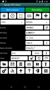
* 現在の座標、高度、速度、進行方向、総移動距離をメートル法、帝国/米国単位、または海事単位で表示します。
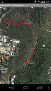
* 現在位置をウェイポイントとして保存し、地図上でどこにいたかを示すトラックログを記録できます。
※KMLファイル、GPXファイルへのデータのインポート、エクスポートが可能です。
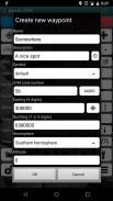
* UTM、MGRS、緯度/経度座標でウェイポイントを手動で入力できます。
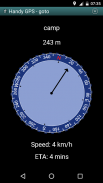
* 「Goto」画面を使用してウェイポイントへの誘導ができ、オプションでウェイポイントに近づくと警告音を鳴らすことができます。
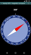
* 磁場センサーを備えたデバイスで動作するコンパス ページがあります。
* ローカル ジオイド オフセットを自動的に計算して高度精度を向上させます
* 一般的なオーストラリアの測地基準系および地図グリッドとともに、世界規模の WGS84 測地系をサポートします。米国では、NAD83 マップに WGS84 を使用できます。
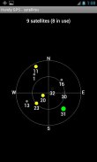
* GPS 衛星の位置と信号強度をグラフで表示します。
* 単純または MGRS グリッド参照を表示できます。
* ウェイポイント間の距離と方向を計算できます。
* 歩行時間を記録し、平均速度を計算するためのオプションのタイマー ラインが含まれています。
* 開発者によって多くのオフトラックウォークで徹底的にテストされています
有料版のみの追加機能:
* 広告なし。
* ウェイポイントとトラックログポイントの数は無制限です。
* オフラインマップ。
* カスタムデータ。
*標高プロファイル。
* アプリから写真を撮ったり、ボイスメモを録音したりできます。
* 現在地を友人に電子メールまたは SMS で送信します。
* 英国グリッド参照。
* 位置精度を向上させるための GPS 平均化、
※日の出と日の入りの時間。
* ウェイポイントとトラックログを CSV ファイルにエクスポートします。
*方位と距離を使用してウェイポイントを投影します。
* トラックログから長さ、面積、標高の変化を計算します。
* カロリーを計算します。
権限: (1) GPS - 現在地を特定するため、(2) ネットワーク アクセス - 標準のマップ レイヤーと OSM タイルにアクセスするため、(3) SD カード アクセス - ウェイポイントとトラックログをロードおよび保存するため、(4) 撮影のためのカメラ アクセス写真*、(5) 近接アラームが機能するように携帯電話がスリープしないようにします、(6) フラッシュライトを制御して、アプリ内からフラッシュライトのオン/オフを切り替えられるようにします、(7) 音声メモ用に音声を録音します*。 (* この機能はアプリの製品版でのみ利用可能です)。
免責事項: このアプリはご自身の責任で使用してください。開発者は、このアプリの使用による紛失や怪我については一切の責任を負いません。モバイル機器のバッテリーが切れる場合があります。長時間のハイキングや遠隔地へのハイキングの場合は、安全のためにバッテリーバンクと、紙の地図やコンパスなどの代替ナビゲーション方法をお勧めします。
Handy GPS lite - バージョン 42.8
(21-11-2024)
Handy GPS lite- APK情報
APKバージョン: 42.8パッケージ: binaryearth.handygpsfreeHandy GPS liteの最新バージョン
他のバージョン


同じカテゴリのアプリ


